Efficient and Reproducible Substrate Mapping with Recreation-grade Sonar Systems [Poster Session]
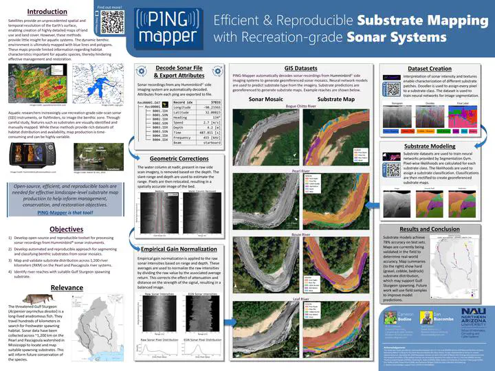 Image credit: Bodine & Buscombe. (2024)
Abstract
Knowledge of the variation and distribution of substrates at large spatial extents in aquatic systems is severely lacking, impeding species conservation and habitat restoration efforts. The introduction of recreation-grade side scan sonar (SSS) instruments, or fishfinders, in the 2000’s has provided researchers with an instrument that is easy-to-deploy and operate, enabling rapid surveys of these environments. However, existing methods for processing sonar mosaics and generating substrate maps requires a high degree of human-intervention and expertise, which limits the accessibility, efficiency, and reproducibility of these approaches. An open-source and automated tool for generating geospatial datasets from recreation-grade sonar instruments is needed to help increase our understanding of aquatic habitats at the site and landscape-level. We introduce PING-Mapper, an open-source and freely available Python-based software for generating geospatial benthic datasets from recreation-grade SSS systems. PING-Mapper is an end-to-end framework for surveying and mapping aquatic systems at large spatial extents reproducibly, with minimal intervention from the user. Version 1.0 of the software (Summer 2022) decodes sonar recordings from any Humminbird® side imaging system, export plots of sonar intensities and sensor-derived bedpicks and generates georeferenced mosaics of geometrically corrected sonar imagery. Version 2.0 of the software, released Fall 2023, extends PING-Mapper functionality by incorporating deep neural network models that automatically locate and mask sonar shadows, calculate independent bedpicks from both side scan channels, and classify substrates at the pixel level. An additional workflow enables normalization of sonar intensity values, or backscatter, effectively correcting attenuation effects and improving overall contrast of the sonar mosaics. This software provides the aquatic research community with an efficient means of surveying aquatic systems and generating substrate maps which will inform fish sampling efforts, habitat suitability models, and planning and monitoring habitat restoration.