An open-source framework to transform recreation-grade sonar systems into scientific mapping instruments [Poster Session]
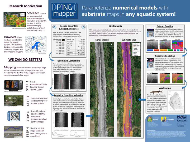 Image credit: Bodine & Buscombe. (2023)
Abstract
Scientific knowledge of the variation and distribution of substrates at large spatial extents in aquatic systems is severely lacking. This is due to existing methods which are limited in scale, require heavy and technically sophisticated survey equipment, or simply a lack of funding for surveying and mapping. Recreation-grade side scan sonar (SSS) instruments, or fishfinders, have demonstrated their unparalleled value in a lightweight and easily-to-deploy system to image benthic habitats efficiently at the landscape-level. Existing methods for generating geospatial datasets from these sonar systems require a high-level of interaction from the user and are primarily closed-source, limiting opportunities for community-driven enhancements. That is why we made PING-Mapper, an open-source software written in Python designed to generate geospatial benthic datasets from recreation-grade SSS systems. Version 1.0 of the software, released Summer 2022, will decode sonar recordings from any existing Humminbird side imaging system, optionally export plots of sonar intensities and sensor-derived bedpicks, and generate georeferenced mosaics of geometrically corrected sonar imagery. Version 2.0 of the software, scheduled for release in Summer 2023, extends the functionality of PING-Mapper by incorporating neural network models which automatically locate and mask sonar shadows, calculate independent bedpicks from both side scan channels, and segment and classify substrates. These enhancements provide the community with an end-to-end framework for surveying and mapping aquatic systems at large spatial extents reproducibly, with minimal intervention from the user.