Impacts of snow cover and extent on timing of wildfires [Research Proposal]
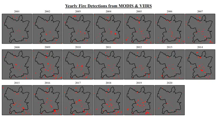 Image credit: Reich et al. (2017)
This is a research proposal developed for INF 599: Team-Based Research final project at Northern Arizona University.
Overview
Predicting wildfire behavior is essential to inform land management policy, community safety, and ecological modeling. However, predicting wildfire timing in a given area is based on localized assessments and not consistent. This study seeks to predict when wildfire season will begin over a given area based on snow cover extent. Study objectives are as follows: 1) Increase understanding of interactions between snow cover and fire. 2) Develop models to predict fire occurrence based on existing trends. Snow coverage plays an important role in maintaining moisture content in soil and fuels, which is a factor in determining an area’s susceptibility to wildfires. Publicly available satellite-derived snow extent data will be used to determine spatial and temporal coverage. These data will be summarized by hydrologic units (HUC12; subwatershed) from the National Hydrography Dataset (NHDPlus HR), each of which will have an average slope and aspect derived from the areas digital elevation model (DEM) and other variables, such as accumulated precipitation and annual high and low temperature. Fire occurrence for a given area is determined using 1km or 375m resolution data from NASA’s Moderate Resolution Imaging Spectroradiometer (MODIS).
Preliminary analysis using data from 2000-2020 shows significant correlation between timing of snowmelt and wildfire occurrence for 21 out of 92 HUC12’s using snow coverage alone. To improve the output of this analysis, we will develop our model within a Bayesian framework that incorporates temporally and spatially explicit data streams (i.e., snow and fire coverage satellite remote sensing data, ground-based measurements, citizen science data). This enables our model to leverage variable spatial/temporal resolution data to create a map of the Colorado Basin showing each HUC12’s susceptibility to wildfire temporally. These risk maps will serve as a predictive tool for future studies and land management policy.
Scientific Merit
A high-resolution regional predictor of wildfire timing for a given better informs future studies modeling fire behavior, flood mitigation, and climate change. The algorithm used to determine a given area’s snow coverage in this study is scalable and applicable to a range of locations beyond northern Arizona. Our model can leverage future data sources, including higher resolution satellite imagery and GPS GNSS point data to improve outputs and aid planning of seasonal fieldwork for site-specific studies. This study is novel for its use of publicly available data at variable spatial and temporal scales to predict an area’s susceptibility to wildfire at high resolution (HUC12’s).
Broader Impacts
The methodology and design of this study will be structured to facilitate reproducibility and support open science initiatives. Aside from the publication, code and model maps being available on DataOne under an open copyright license, all aspects of the study will be documented on public repositories (GitHub) in a tutorial format. This approach will educate participants in interfacing with remote sensing platforms, interpret Bayesian modeling outputs, and show how to successfully run this analysis for their area of interest.
The products created from this proposal are valuable for any land management agency, tribe, or counties in areas with wildfires and snow. Resource allocation of personnel will be better predicted over smaller scales, improving logistics and constraining budget. In addition, collaboration with local schools and tribes to support citizen science campaigns for fire and snow observations increases modeling accuracy and fosters stewardship through educational outreach. This study will present its findings through multiple STEM and wildfire conferences nationally and within northern Arizona. We will also host four two-day workshops for federal and state land managers to generate and interpret their own risk maps at Northern Arizona University.